East Hampshire
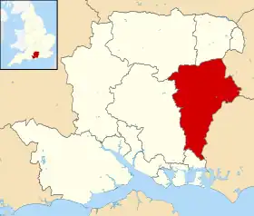
East Hampshire est un district non métropolitain du Hampshire, en Angleterre. Comme son nom l'indique, il est situé dans l'est du comté, à la frontière des comtés du Surrey et du Sussex de l'Ouest. Son chef-lieu est Petersfield.
| East Hampshire | |
| |
| Administration | |
|---|---|
| Pays | |
| Statut | District non métropolitain |
| Région | Angleterre du Sud-Est |
| Comté | Hampshire |
| Chef-lieu | Petersfield |
| Code ONS | 24UC |
| Démographie | |
| Population | 116 000 hab. (est. 2011) |
| Densité | 226 hab./km2 |
| Rang | 186e / 326 |
| Géographie | |
| Coordonnées | 51° 00′ 20″ nord, 0° 54′ 30″ ouest |
| Superficie | 51 440 ha = 514,4 km2 |
| Rang | 89e / 326 |
Composition
Le district est composé des villes et paroisses civiles suivantes :
- Alton
- Beech
- Bentley
- Bentworth
- Binsted
- Bramshott and Liphook
- Buriton
- Chawton
- Clanfield
- Colemore and Priors Dean
- East Meon
- East Tisted
- Farringdon
- Four Marks
- Froxfield and Privett
- Froyle
- Grayshott
- Greatham
- Hawkley
- Headley
- Horndean
- Kingsley
- Langrish
- Lasham
- Lindford
- Liss
- Medstead
- Newton Valence
- Petersfield
- Ropley
- Rowlands Castle
- Selborne
- Shalden
- Sheet
- Steep
- Stroud
- West Tisted
- Whitehill
- Wield
- Worldham
Cet article est issu de Wikipedia. Le texte est sous licence Creative Commons – Attribution – Partage à l’identique. Des conditions supplémentaires peuvent s’appliquer aux fichiers multimédias.